Application Analysis of Radar Level Technology in Urban Flood Monitoring
With the continuous expansion of urban construction, infrastructures such as underpasses, underground spaces, bridge culverts, and drainage pipeline networks are becoming increasingly complex. Under heavy rainfall or extreme weather conditions, localized drainage capacity limitations are more easily exposed, leading to urban flooding, traffic disruption, and operational risks for underground facilities.
Urban waterlogging not only affects daily transportation but can also trigger cascading impacts on pumping stations, power systems, communication networks, and underground structural safety. Therefore, establishing a stable, continuous, and remotely accessible water level monitoring system has become a fundamental requirement for modern urban flood control systems and smart water management infrastructure.
Against this background, radar level transmitters have become widely adopted in urban flood monitoring applications due to their non-contact measurement principle, high-precision signal processing capability, and strong adaptability to complex environmental conditions.
1. Why Radar Level Technology is Required for Urban Flood Monitoring
Urban flooding is typically caused by a combination of factors rather than a single source, including short-duration heavy rainfall, overloaded drainage systems, pipeline blockage, low-lying terrain, and river backflow.
Traditional monitoring methods such as manual inspection, float-based level switches, or pressure sensors are still used in some applications. However, in complex urban environments, they face several limitations:
- Easily affected by sediment and floating debris, leading to jamming or inaccurate readings
- High corrosion risk under long-term submerged conditions, resulting in frequent maintenance
- Difficult installation and inspection in confined underground environments
- Discontinuous data acquisition, making trend analysis unreliable
In critical locations such as underground passages, stormwater wells, bridge culverts, and pumping station collection pits, any delay or interruption in data collection can significantly reduce decision-making efficiency and even result in missed flood response opportunities.
Compared with these methods, radar-based level measurement operates in a non-contact manner, enabling measurement without direct contact with water. This effectively eliminates issues caused by contamination, corrosion, and mechanical wear, making it more suitable for urban flood monitoring applications.
2. Working Principle of Radar Level Measurement

Radar level transmitters operate based on high-frequency electromagnetic wave ranging principles.
The measurement process includes:
- The radar emits high-frequency microwave signals toward the water surface
- The signal is reflected from the liquid surface
- The sensor receives the echo signal
- The system calculates the time difference between transmission and reception
- The distance is converted into real-time water level data
Since the measurement process does not require direct contact with the medium, it is not affected by water quality, floating debris, sediment, or chemical corrosion. In addition, radar measurement provides fast response capability, enabling it to capture sudden water level rises during short-term heavy rainfall events—an essential capability for flood warning systems.
3. Core Technical Advantages of Radar Level Transmitters
3.1 80GHz High-Frequency Radar for Improved Environmental Recognition
Radar level transmitters using 80GHz FMCW technology offer significantly improved performance compared with traditional lower-frequency radar systems.
The 80GHz signal features a narrower beam angle and higher energy concentration, allowing more precise targeting of the liquid surface. This reduces interference caused by surrounding structures and improves echo clarity and measurement accuracy.
In urban flood monitoring environments, installation conditions are often highly complex, including confined underground spaces, reinforced concrete structures in bridge culverts, narrow stormwater wells with multipath reflections, and pumping stations with turbulent water surfaces.
In such environments, low-frequency radar systems are more susceptible to sidewall reflections, structural scattering, and multipath interference, resulting in unstable or distorted signals.
With its shorter wavelength and higher directionality, 80GHz radar significantly reduces beam divergence and improves resolution, enabling clear separation between true water surface echoes and structural interference. This ensures stable and continuous measurement performance even in highly complex conditions.
3.2 Non-Contact Measurement Design Reducing Maintenance Requirements
In urban drainage environments, the measured medium often contains sediment, oil, leaves, plastic waste, and suspended solids. In addition, combined sewer systems and pumping station basins may experience sediment accumulation over time.
These conditions create serious challenges for traditional contact-based sensors, including probe fouling, measurement drift, mechanical blockage, and corrosion, all of which increase maintenance frequency and risk of failure.
Radar level transmitters eliminate these issues through a fully non-contact design. The device is installed above the liquid surface and measures distance using electromagnetic wave reflection without contacting the medium.
This structural advantage significantly improves long-term reliability, especially in underground tunnels, stormwater wells, low-lying drainage areas, and pumping station sumps where maintenance access is limited. It reduces the need for cleaning, calibration, and manual intervention, thereby lowering operational costs.
3.3 Strong Anti-Interference Capability for Complex Urban Conditions
Urban flood monitoring environments are characterized by multiple interference sources, including dynamic water surface fluctuations, structural reflections, environmental changes, and electromagnetic noise.
In confined spaces such as underground structures or bridge culverts, multipath reflections are common. During heavy rainfall or wind conditions, water surface disturbances become more intense. In industrial or urban infrastructure areas, electromagnetic interference from electrical equipment may also affect signal stability.
Radar level transmitters use advanced echo processing algorithms to filter out unwanted reflections from structures such as walls, brackets, and pipelines, retaining only valid water surface signals.
In flood management systems, data continuity and trend reliability are more important than single-point accuracy. Stable and continuous data allows accurate detection of rising water trends, flood risks, and the need for emergency actions such as pump activation or drainage diversion.
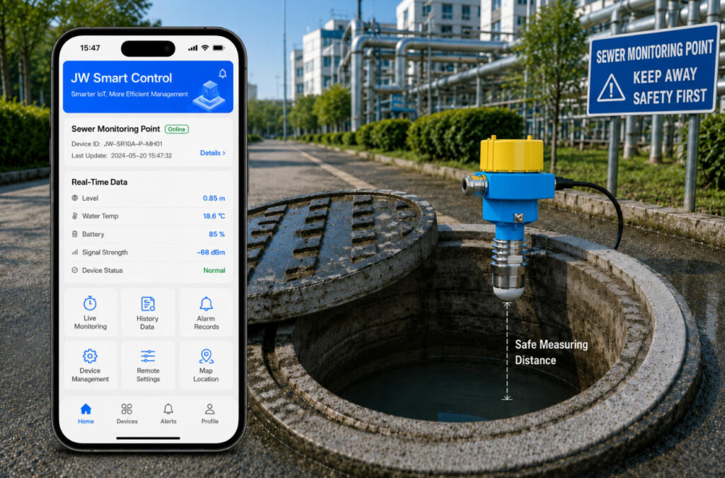
3.4 Remote Connectivity for Smart Water Management Systems
With the development of smart city infrastructure, radar level transmitters have evolved from simple measurement devices into key nodes of urban sensing networks.
Radar level systems support multiple industrial communication protocols and can be integrated into IoT platforms, SCADA systems, and centralized water management systems for real-time monitoring and data analysis.
Typical installation locations include flood-prone roads, underground passages, bridge culverts, stormwater wells, pipeline nodes, and pumping stations.
When water levels exceed preset thresholds, the system can automatically trigger alarms and activate pumps, gate controls, or emergency response actions.
This enables a closed-loop operational system:
Monitoring → Analysis → Early Warning → Automated Response
4. Typical Application Scenarios in Urban Flood Monitoring
4.1 Low-Lying Road Water Level Monitoring
Real-time monitoring of water depth in underpasses and flood-prone roads for traffic control and drainage response.
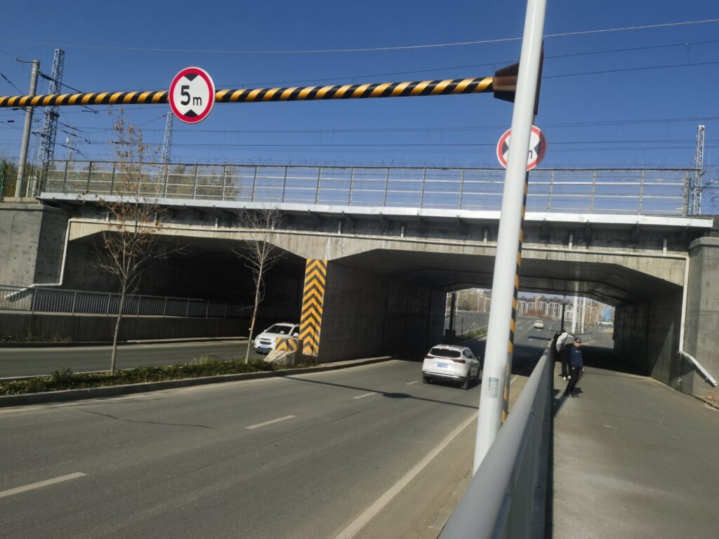
4.2 Underground Passage and Bridge Culvert Monitoring
Provides early warning for rapid water accumulation in confined underground spaces, ensuring safety for pedestrians and vehicles.
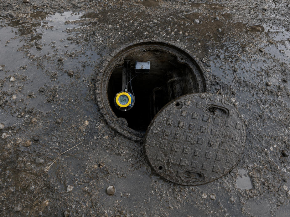
4.3 Stormwater Pipeline and Manhole Monitoring
Helps identify blockage, surcharge conditions, backflow, and drainage inefficiencies in urban drainage systems.
4.4 Pumping Station Water Level Control
Provides real-time data for pump control decisions, improving drainage efficiency and reducing energy consumption.
5. From Monitoring to Early Warning: Enhancing Urban Flood Resilience
By deploying radar-based monitoring networks, urban management systems can transition from traditional manual inspection and experience-based decision-making to a data-driven framework combining:
Real-time monitoring + data analysis + automated warning + coordinated control
Continuous data acquisition enables trend analysis across multiple monitoring points. When abnormal water level increases are detected, the system can automatically trigger alerts and support emergency decision-making, improving response efficiency and long-term drainage system optimization.
Conclusion
The core of urban flood management lies in timely detection, accurate assessment, and rapid response.
Radar level transmitters provide a reliable foundation for urban drainage and flood monitoring systems through high-frequency radar technology, non-contact measurement, advanced signal processing, and remote connectivity capabilities.
With the continued development of smart city infrastructure and digital water management systems, radar level monitoring is expected to become a standard component of urban flood control systems, contributing to safer, more efficient, and more resilient urban environments.