JWrada® Radar Level Meters for Reservoir and Dam Water Level Measurement
In water resource management, monitoring the water level of reservoirs and dams is crucial for ensuring water supply safety, operational management, and flood control. Achieving efficient and reliable water level measurement requires selecting appropriate level measurement instruments. Among various level measurement technologies, radar level meters (Radar Level Meter / Radar Water Level Meter) have become the preferred choice for reservoirs due to their non-contact measurement, high accuracy, and strong adaptability.
Among these, the Jiwei JWrada®-21 and JWrada®-22 series radar level meters not only inherit the measurement advantages of radar technology but also achieve independent innovation in intelligent software, remote calibration, and field applications, demonstrating unique core competitiveness.

JWrada®-21/22 Radar Level Meters: Intelligent Software and Remote Calibration Advantages
1. Advantages of Radar Level Meters in Reservoir Monitoring
Traditional level measurement technologies include float level meters, ultrasonic level meters, and guided wave radar meters. However, for large reservoirs and dams, complex environmental conditions, significant temperature changes, water evaporation, and waves can cause measurement errors, signal interference, or maintenance difficulties for traditional instruments.
JWrada® radar level meters use high-frequency microwave pulse principles. Radar waves are emitted from the transmitter, reflected by the water surface, and received by the antenna. The water level is calculated based on the time delay. Their core advantages include:
- Non-contact measurement: Radar waves travel through air without contacting the water, avoiding contamination and corrosion.
- High accuracy and stability: High-frequency microwaves provide strong anti-interference capability, maintaining stable measurements under waves, steam, and foam.
- Wide applicability: Suitable for reservoirs, water tanks, rivers, and municipal water supply, adapting to extreme weather and remote conditions.
Compared with ultrasonic level meters, radar level meters are less affected by atmospheric temperature changes, steam, and fog, making them ideal for critical sites like reservoirs and drinking water storage tanks.
2. JWrada® Core Competitiveness: Intelligent Software and Cloud-Based Remote Calibration
JWrada® series radar level meters combine high-precision hardware with intelligent software, including the following functions:
- Software updates: Push the latest algorithms and functions via the cloud, eliminating manual upgrades.
- Operational calibration: Adjust parameters in real time for various water level environments.
- Parameter setting: Configure measurement intervals, output signal types, and alarm points remotely.
- Fault code monitoring: Diagnose device status remotely, quickly locate problems, and improve maintenance efficiency.
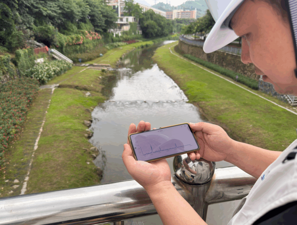
Importantly, JWrada® supports one-on-one cloud-based remote calibration. Engineers can remotely collaborate with on-site personnel, view echo curves and EFT (Echo Fourier Transform) curves in real time, and analyze water surface fluctuations and noise. This capability is currently unavailable from other domestic radar level meter manufacturers and enables a combination of remote precision calibration and professional analysis.
3. Application of Echo Curves and EFT Curves

Reservoir environments are complex, for example:
- Water surface fluctuations causing unstable echoes
- Wave-induced interference peaks
- Temperature gradients from sunlight and evaporation
Echo curves record the intensity of radar reflection signals over distance, allowing engineers to quickly identify water surface height and abnormal signals.
EFT curves analyze echo signals in the frequency domain, helping identify environmental interference and filter noise.
By combining echo and EFT curves, engineers can:
- Monitor water level trends continuously
- Optimize parameters such as gain, dead zone, and filtering for precise measurement
- Analyze faults to quickly identify abnormal reflections, interference, or device issues, reducing false alarms
This integration of hardware measurement and intelligent software analysis allows JWrada® radar level meters to maintain stable and reliable performance in complex reservoir conditions.
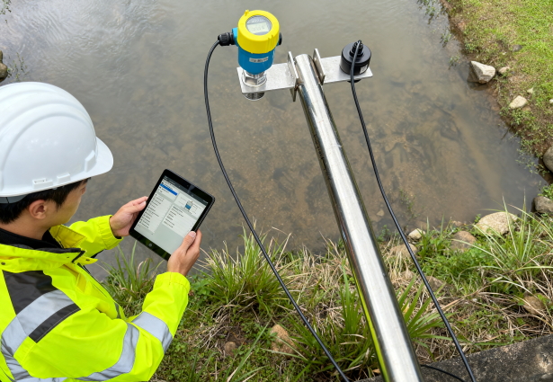
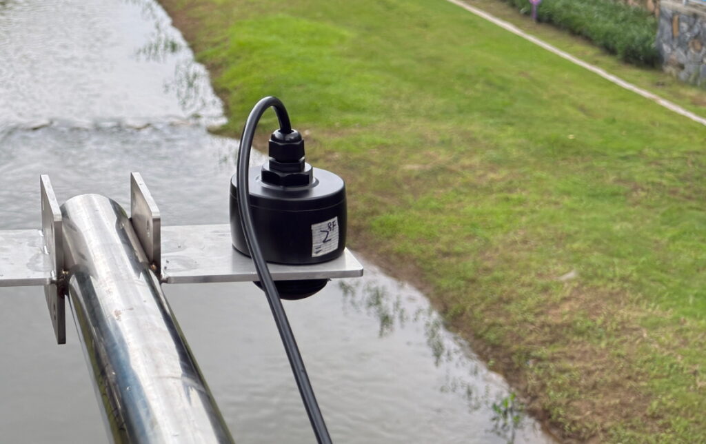
4. Case Study: Yangjiang Reservoir Remote Monitoring Project
In a medium-sized reservoir project in Yangjiang, the site was remote with limited infrastructure. Traditional level meters were unsuitable due to maintenance difficulty and measurement errors. The project adopted JWrada®-22 radar water level meters, achieving:
- Remote data acquisition and transmission: Engineers could view water levels remotely via the cloud, reducing the need for frequent on-site maintenance.
- Real-time echo and EFT analysis: On-site water surface fluctuations were addressed by remotely optimizing measurement parameters, ensuring high-precision readings.
- Customized parameter optimization: Gain, filtering, and dead zone settings were tailored for wind, waves, steam, and temperature variations, ensuring long-term stable operation.
- Reduced maintenance and increased reliability: No mechanical contact parts and remote cloud calibration reduced site maintenance frequency, significantly lowering operational costs.
After 12 months, measurement accuracy remained within ±1 mm, with data stability at 99%, fully meeting reservoir management and flood control requirements.
5. Application and Technical Advantages of JWrada® Radar Level Meters in Reservoirs and Dams
In practical applications, engineers should leverage the software intelligence and cloud-based remote calibration of JWrada® radar level meters to ensure long-term, high-precision operation. The JWrada® series (JWrada®-21 / 22) offers:
- Remote software updates
- Operational calibration and parameter setting
- Fault code monitoring
- Real-time echo and EFT curve analysis
During calibration, parameters can be optimized according to water surface fluctuations, environmental interference, and temperature variations, ensuring each device performs optimally in its unique environment.
Data reliability management is critical. JWrada® allows maintenance personnel to monitor echo and EFT curves regularly, identifying potential issues such as water surface interference, sediment accumulation, or floating debris, preventing measurement errors from affecting water resource management and flood control.
Protection and installation: Reservoirs and dams often experience strong waves, high humidity, and large temperature variations. JWrada® supports protective covers and specialized mounts to ensure stable radar signal transmission and extend device life. For open reservoirs or dam crest measurements, devices resist waves and sunlight, avoiding signal distortion. Installation angles and antenna positions can be adjusted for sites with floating debris or high sediment content, while cloud-based calibration enhances measurement accuracy.
Cloud-based remote calibration and operation is another key advantage. Engineers can collaborate one-on-one with on-site personnel, analyze echo and EFT curves, and remotely adjust parameters for dynamic optimization. For multi-reservoir or dam systems, cloud monitoring platforms centralize water level data, automatically generate alarms and reports, improving water resource scheduling and emergency response. For instance, in a southern reservoir project, JWrada® radar level meters enabled full-range continuous water level monitoring and issued early warnings during heavy rain.
Future development: Jiwei Automation plans to launch low-power, solar-powered radar level meters, further enhancing automation and green monitoring for reservoirs and dams. These products will integrate high-efficiency measurement modules and intelligent power management, enabling 24/7 monitoring in remote reservoirs or small dams without external power. Combined with cloud-based calibration, engineers can optimize parameters remotely without frequent site visits, reducing operational costs and increasing reliability.
In summary, leveraging JWrada® radar level meters’ software advantages, cloud remote calibration, echo and EFT curve monitoring, and protective installation ensures high-precision, long-term stable, and low-maintenance water level measurement. Jiwei Automation’s future development of solar-powered, low-power radar level meters will provide reliable, environmentally friendly, and intelligent solutions for remote reservoirs and small dams, supporting modern water resource management.
6. Conclusion
The JWrada®-21 / 22 series radar level meters demonstrate unique competitiveness in reservoir water level monitoring through self-developed software and intelligent cloud-based remote calibration. Key highlights include:
- Intelligent software: Full coverage for parameter setting, operational calibration, fault code monitoring, and software updates.
- Cloud-based remote calibration: Engineers can collaborate one-on-one on-site, view echo and EFT curves in real time, and optimize measurement parameters.
- High adaptability: Stable measurement under waves, steam, and temperature variations.
- Reliability and low maintenance: No mechanical contacts, remote monitoring reduces on-site maintenance frequency.
Through remote calibration and parameter optimization, JWrada® radar level meters enable precise, reliable, and long-term stable reservoir water level measurement, providing strong data support for urban water supply, flood control, and water resource management.