Jiwei JWrada® Radar Level Transmitters in a Watercourse Monitoring Project
With the increasing frequency of extreme weather events and the continuous advancement of smart water management, the demand for real-time water level monitoring in rivers, reservoirs, and urban water systems has been steadily rising. To better cope with low water levels during droughts and flooding risks during heavy rainfall seasons, a watercourse monitoring project in Mianyang, Sichuan Province, implemented an IoT-based remote monitoring solution for continuous, real-time data collection and early warning management.
In this project, the Jiwei-developed JWrada® radar level transmitters serve as the core measurement devices, providing safe, stable, and accurate water level monitoring. Compared to traditional manual measurements, the JWrada® series offers a more intelligent and efficient digital solution. Through wireless transmission and remote monitoring, management personnel can track water level changes in real time and take timely flood prevention or water resource management actions.
Traditional Water Level Measurement vs. Modern Radar Monitoring
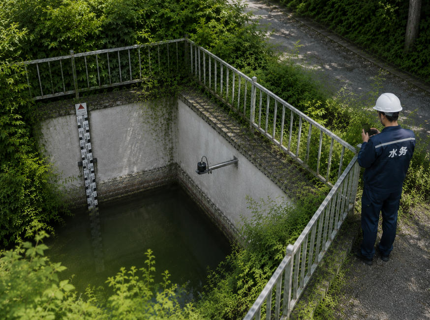
In the early stages of the project, river water levels were mainly measured using staff gauges or manual inspections. These traditional methods have limitations, including delayed data updates, high operational risks, and difficulty accessing complex river sections.
Particularly during heavy rain or at night, manual measurements are not only inefficient but also pose significant safety hazards. To improve monitoring efficiency and smart water management, the project adopted JWrada® radar level transmitters for modernization.
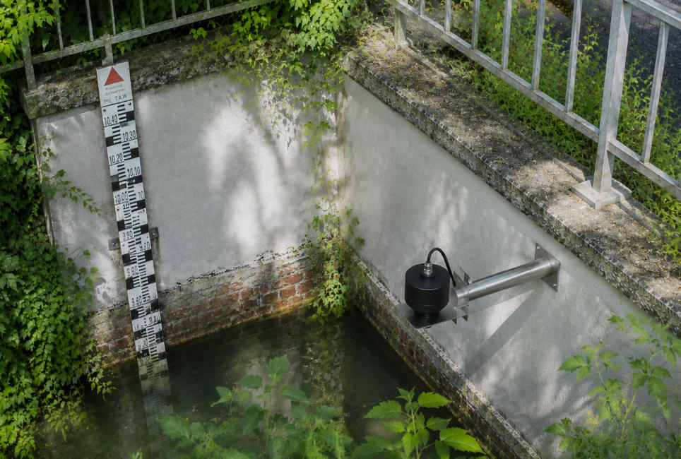
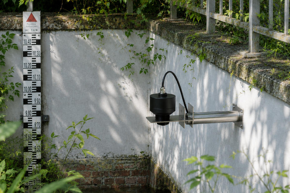
JWrada® radar level transmitters employ high-frequency radar waves for non-contact measurement, enabling all-weather automated water level monitoring. The devices can be installed on bridges, riverbanks, or sluices, reducing the need for staff to enter hazardous areas and significantly lowering the risk of on-site operations.
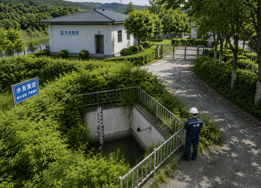
Project Overview: IoT Watercourse Monitoring System in Mianyang
To strengthen river water management, this project established a structured water level monitoring network for centralized remote management. The main objectives are:
- Real-time collection of water level data
- Automatic alert generation
- Early response to flood and drought risks
- Enhanced smart water management
Currently, JWrada® radar level transmitters have been deployed across multiple key river sections. All measuring points transmit data in real time to a central monitoring platform, where operators can set individual alert thresholds for different areas.
When water levels rise rapidly, the system automatically triggers alerts to assist management in timely flood prevention. During dry periods, water resource changes can be monitored to optimize allocation. Compared with manual measurement, JWrada® radar level transmitters provide:
- Real-time automated monitoring
- Remote data access
- Unattended operation
- Automatic alerts
- Historical data recording and analysis
This significantly enhances the intelligence and efficiency of river management.
Challenges in Complex Watercourse Monitoring
Watercourse monitoring environments are often highly complex, especially in mountainous or natural waterways, presenting multiple challenges:
- Narrow and winding watercourses
- Dense vegetation along riverbanks
- Floating debris on the water surface
- Frequent heavy rain and fog
- Significant temperature fluctuations
- Difficult access in remote areas
Moreover, sudden water level changes are hard to detect promptly with traditional manual monitoring. JWrada® radar level transmitters were chosen for this project due to their high reliability, stability, and strong anti-interference capability, making them well-suited for long-term, continuous monitoring in complex natural watercourses.
Advantages of JWrada® Radar Level Transmitters
Precise Measurement
JWrada® radar level transmitters feature a small radar beam angle of approximately 6°, enabling precise water level measurements even in narrow rivers, under bridges, or in densely vegetated areas. The concentrated beam reduces interference and accurately reflects small variations in water surface height, improving measurement precision and reliability.
The devices have no blind spots and can quickly detect sudden water level rises or drops without being installed at excessive heights. This is particularly important during floods or rapid water level changes, providing timely data for decision-making, flood warnings, and water resource management.
Compared to traditional ultrasonic level sensors, radar measurements are unaffected by wind, temperature, humidity, vapor, or surface disturbances. Even in fog, rain, snow, or cold conditions, JWrada® radar level transmitters maintain high stability and measurement accuracy. Equipped with intelligent echo processing, the devices filter false echoes, ensuring reliable and usable data even in environments with floating debris, vegetation, or leaves.
These advantages make JWrada® radar level transmitters suitable not only for urban rivers and mountainous streams but also for reservoirs, lakes, and other complex natural water bodies, providing robust support for smart water management, river monitoring, and flood warning systems.
Strong Anti-Interference
JWrada® radar level transmitters offer excellent anti-interference capabilities:
- Unaffected by water surface fluctuations
- Resistant to floating debris
- Not obstructed by vegetation
- Stable under temperature variations
- Reliable in foggy or rainy conditions
Smart echo processing allows the system to automatically filter false echoes, improving measurement stability and reliability.
Non-Contact Measurement Enhances Safety
Unlike traditional staff gauges or float measurements, JWrada® radar level transmitters use non-contact measurement technology. Operators do not need to enter the river or stand at bridge edges. By connecting via Bluetooth to the Jiwei SmartControl App (international version: JW Tools), field personnel can safely perform on-site calibration and parameter settings, greatly reducing operational risks.
Low-Power Operation and Solar-Assisted Power Supply
Some monitoring points are located in remote river sections with limited power supply. JWrada® radar level transmitters can be powered using solar-assisted systems, enabling long-term low-power operation.
By adjusting measurement intervals and data transmission frequency, the devices can continuously operate unattended, reducing maintenance frequency and costs. The compact and low-power design makes them suitable for long-term monitoring in mountainous rivers, reservoirs, and remote natural environments.
Cloud-Based Monitoring and Remote Management
All measuring point data is centrally managed through a cloud platform, enabling remote monitoring and intelligent alerting. Operators can view in real time:
- Current water levels
- Historical trends
- Alert logs
- Device operating status
- Data changes
The system supports automatic alerts and remote management, improving flood warning efficiency and providing reliable data for emergency planning.
Bluetooth Wireless Commissioning Enhances Efficiency
JWrada® radar level transmitters support advanced Bluetooth wireless commissioning, allowing field engineers to safely and quickly perform setup without opening the device casing or entering water bodies.
Using a smartphone or tablet, engineers can:
- Set Parameters: Adjust measurement range, alert thresholds, and data collection intervals on-site.
- Read Data: Access real-time water levels, echo signal strength, signal quality, and device status.
- Analyze Echo Curves: Examine radar echo patterns to optimize measurement precision.
- Perform Diagnostics: Detect sensor anomalies, signal degradation, or communication faults.
- Copy Parameters: Duplicate settings to multiple devices for efficient large-scale deployment.
- Commission Devices: Calibrate, test accuracy, and verify echo signal quality, ensuring instruments are fully operational.
Typically, each device can be commissioned in 2–5 minutes, greatly accelerating project deployment, reducing labor, and lowering costs. Bluetooth commissioning performs reliably even in complex environments with dense vegetation or bridge obstructions.
Future Prospects for IoT Watercourse Monitoring
The IoT watercourse monitoring system implemented in Mianyang demonstrates the significant advantages of wireless radar monitoring over traditional methods:
- High-precision, real-time monitoring
- Remote and wireless management
- Reduced manual inspections
- Early flood warning
- Support for large-scale network expansion
- Lower long-term maintenance costs
The network can be further expanded to cover more rivers, reservoirs, and urban drainage systems, enhancing the digital water management capabilities of the region.
Summary
Through Jiwei JWrada® radar level transmitters, the Mianyang watercourse monitoring project has established an efficient, intelligent, and reliable real-time monitoring system.
With a small beam angle of approximately 6°, high-precision radar measurement, low-power design, and remote wireless monitoring, JWrada® series devices operate stably even in complex natural watercourses. Compared to traditional manual methods, they improve data timeliness, operational efficiency, and reduce maintenance complexity and costs.
This project highlights the value of JWrada® radar level transmitters in smart water management, river monitoring, and flood warning, providing a reliable reference for future digital water management initiatives.